
Out of all the amazing Africa landforms, lakes, and rivers, the Congo River stands out as one of the most important to the people of Africa. In the list of facts below you will find information on why this river is important to Africa along with information on where it is located, and what the river's source is. This information is written for both kids and adults.
Facts about the Importance of the Congo River
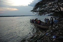
- The Congo River is the main transportation source in Central Africa. The river along with all the streams that lead into it provide over nine thousand miles (14,500 kilometers) of navigable shipping routes in Central Africa. A tremendous amount of goods are transported on the river every day.
- The Congo River is an extremely powerful river; in fact it is the most powerful river in Africa. On average one million four hundred thousand cubic feet of water (41,000 cubic meters) flows into the Atlantic Ocean every second from the river. There are approximately forty hydropower plants along the river that utilize this power to provide energy for the African continet
- It is the second longest river in Africa (the Nile is the longest).
- It is the ninth longest river in the world.
- The Congo River is the deepest river in the world. It reaches depths of over 750 feet (230 meters).
- The river gets its name from the ancient Kongo Kingdom which existed near the mouth of the river.
- The river runs through the Congo rainforest which is the second largest rain forest in the world.
- It is also called the Zaire River.
- The Congo River's sources are in the mountains and highlands of the East African Rift, as well as Lake Tanganyika and Lake Mweru.
- The Congo River is so powerful that if has the potential to supply all of sub-Saharan Africa's electricity needs.
- In 1482 Diego Cao was the first European known to sight and enter the Congo River.
- The main tributaries are the Ubangi, Sangha, and Kasai.
- There are more than 4,000 islands in the river; over fifty are at least ten miles long.
- The river crosses the equator twice.
- The river discharges a volume of water that is second only to the Amazon River.
- Numerous cataracts (large or high waterfalls), dangerous rapids, and numerous islands make navigation difficult or impossible in certain areas of the river.
- Two countries are named after the river, they are The Democratic Republic of the Congo and the Republic of the Congo.
- The amount of water flowing out of the river is fairly constant year round due to the fact that some part of the river is always in a rainy season.
- Approximately seven hundred fish species have been recorded living in the Congo River. The total is probably much larger.
- The Congo River formed approximately 1.5 - 2 million years ago during the Pleistocene period.
The Congo River is named after the ancient Kingdom of Kongo, which inhabited the lands at the mouth of the river at the time of European discovery. The Democratic Republic of Congo and Republic of Congo, both countries lying along the river's banks, are named after it. Between 1971 and 1997 the government of then-Zaire referred to it as the “Zaire River.”
History
Before continental drift opened the South Atlantic Ocean, the Congo was the upper part of a river roughly 7,500 miles (12,000 kilometers) long that flowed west across the parts of Gondwanaland that are now Africa and South America. Except for the beginning and end of its course, the river is uniformly elevated.
Bantu-speaking people have lived along the Congo for at least two thousand years, supporting themselves with fish from the river and farms on the fertile lands between the river and forest. A powerful kingdom of the Kongo people, centered at the mouth of the river, emerged by the 1300s.
Exploration
The Portuguese explorer Diogo Cão (Diogo Cam, currently) entered the Congo estuary on a voyage from 1482 to 1484 and claimed the area for his king. Those who tried to sail upriver encountered a narrow gorge that compressed the water into a powerful opposing current. In the river's final 220 miles from the edge of the central plateau to the coast, the Congo River drops more than a thousand feet and has 32 rapids. Difficult terrain made exploration on foot also treacherous. Following Cam, more than three hundred years elapsed before serious exploration of the Congo was undertaken.
Francisco José de Lacerda, a Portuguese explorer, reached the copper-rich Katanga region from the east in 1798, as did Arab traders in the first half of the 1800s. The Arabs extended their influence over the eastern Congo River Basin, engaging in the slave and ivory trades. In 1816 a British expedition went as far as Isangila. Scottish explorer and missionary David Livingstone visited the Luapula and Lualaba rivers in 1871, believing them to be sources of the Nile.
Henry Morton Stanley was the first European to navigate the river's length and report that the Lualaba was not a source of the Nile, as had been suggested. He returned on behalf of King Leopold of Belgium in 1876 and claimed huge swaths of land in the Conger River basin for the king, an area more than 76 times the size of Belgium. By 1885 Leopold ruled this huge area as his personal domain through his private army, the Force Publique. His legacy is one of exploitation and human rights abuses such as slavery and mutilation of the peoples. He was eventually forced to cede this land to Belgium in 1908.
Several other European explorers traveled up the Congo's tributaries in the 1880s, mapping out ten thousand miles of navigable waterways that were linked together.
Though trade in goods was the initial impetus for the Europeans, they quickly discovered that the slave trade was much more lucrative, and the river was the means to deliver them to the coast from inland areas once the supply of slaves dwindled on the coast. As the wealth from the slave trade filtered inland, the demand for slaves grew, leading to raids by some groups and migrations by others to escape the slavers. But the increased trade and multiplication of towns along the river had the unforeseen benefit of lifestyles becoming more similar and new crops and technologies being shared.
Source
The sources of the Congo River are in the highlands and mountains of the Great Rift Valley, as well as Lake Tanganyika and Lake Mweru, which feed the Lualaba River, becoming the Congo below Boyoma Falls. The Chambeshi River in Zambia is generally taken as the source of the Congo, in line with the accepted practice worldwide of using the longest tributary, as with the Nile River.
Course
Because the watershed of the Congo drains from both the Northern and Southern Hemisphere, it does not have the great seasonal fluctuations in water level as other great rivers. Its flow is relatively stable because part of its watershed is always in the zone of rain. The Upper Congo abruptly ends with Stanley Falls, a 60-mile stretch of rapids.
Stanley Falls gives way to the Middle Congo, a thousand-mile stretch of navigable river, nine miles wide in some areas. Along this quiet stretch of river is the city of Kisangani in the Democratic Republic of Congo. Kisangani is located where the Lualaba River becomes the Congo River north of the Boyoma Falls, and was the site of the first settlement of Henry Morton Stanley.
The Congo flows generally west from Kisangani just below the falls, then gradually bends southwest, passing by Mbandaka, joining with the Ubangi River, and running into the Malebo Pool (Stanley Pool), a fifty-mile lake. Here the river slows to a virtual stand-still for 20 miles. At this point it is 15 miles wide and is and flanked by the capital cities of Kinshasa and Brazzaville.
Kinshasa (formerly Léopoldville) and Brazzaville are on opposite sides of the river at the Pool, then the river narrows and falls through a number of cataracts in deep canyons (collectively known as the Livingstone Falls), running by Matadi and Boma, and into the sea at the small town of Muanda.
The river then flows into Livingstone Falls, a series of rapids and cataracts 220 miles long. There are some 32 cataracts, having as much power as all rivers and falls in the United States combined. The final one hundred miles to the Atlantic Ocean from the end of the falls is fully navigable.
The Congo and its tributaries drain parts of Central African Republic, Cameroon, Angola, Zambia, Democratic Republic of the Congo, Republic of the Congo, Equatorial Guinea and Gabon.
Ecology
The northern and southern parts of the basin are characterized by open grasslands and scattered trees. Wildlife is abundant along the river, which itself harbors more than two hundred species of fish.
According to the Water Resources Atlas, the Congo Basin Area encompasses 3,730,881 square miles.
Although the Congo water discharge levels were unstable throughout the second half of the twentieth century, the hydrologic balance of the river has provided some relief from the drought that has afflicted the river basin.
In 1999, the World Commission on Water for the Twenty-First Century found that the Congo was one of the world's cleanest rivers, in part due to the lack of industrial development along its shores until that time.
However, the situation is changing. Major threats to the large tropical rainforests and savannas are occurring due to increasing population and its demands. Uncontrolled hunting and fishing, illegal logging and the poaching of large mammals, deforestation, unplanned urban expansion and unrestrained extraction of oil and minerals are some of the major economic and environmental issues confronting the region.
Economic importance
With railways now bypassing the three major falls (Matadi-Kinshasa; Kisangani-Ubundu; Kindu-Kongolo), the Congo River and its tributaries form a system of navigable waterways approximately nine thousand miles (14,480 kilometers) long, with much of the trade of central Africa passing along it, including copper, palm oil (as kernels), sugar, coffee, and cotton.
The chief ocean port is Matadi, with its associated oil port, Ango Ango; the chief river ports are Kinshasa and Kisangani. River steamers operate throughout the year between Kinshasa and Kisangani.
The Congo River is Africa's largest potential source of hydroelectric power; the most valuable site is along Livingstone Falls, where the first phase of the Inga Power Project has been completed. In spite of government initiatives, hydroelectric power is underdeveloped.
In February 2005, South Africa's state-owned power company, Eskom, announced a proposal to increase the capacity of the Inga dramatically through improvements and the construction of a new hydroelectric dam. The project would bring the maximum output of the facility to 40 GW, twice that of China's Three Gorges Dam.
Tributaries
Course and Watershed of the Congo River with countries marked
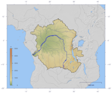
Course and watershed of the Congo River with topography shading
- Inkisi
- Nzadi
- Nsele (south side of Pool Malebo)
- Bombo
- Kasai (between Fimi and Congo, known as Kwa)
- Fimi
- Kwango
- Sankuru
- Likouala
- Sangha
- Ubangi
- Mbomou
This is dummy text. It is not meant to be read. Accordingly, it is difficult to figure out when to end it. But then, this is dummy text. It is not meant to be read. Period.
ConversionConversion EmoticonEmoticon